
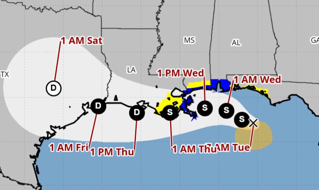
America's Gulf Coast is on high alert after the National Hurricane Center (NHC) issued urgent tropical storm warnings and advisories early Tuesday morning, as Tropical Storm Bertha began churning menacingly off the coast of Florida. Communities from the Florida Panhandle all the way to Louisiana are now bracing for impact.
A robust tropical storm warning has been activated, spanning from the Alabama–Florida border westward to the critical juncture of Louisiana’s Jefferson and Plaquemines parishes. This critical alert was confirmed by the NHC in its 8 a.m. ET update, underscoring the immediate danger.
Further west, a tropical storm watch is now in effect, covering areas from the border of Bay and Gulf counties in Florida, stretching to the Florida–Alabama line. Louisiana is also under vigilance, with watches extending from west of Jefferson and Plaquemines parishes to Morgan City, including the vital metropolitan New Orleans, Lake Pontchartrain, and Lake Maurepas region.
For citizens impacted, it's crucial to understand the distinction: a warning signals that tropical storm conditions are expected within the next 36 hours, demanding immediate preparation. A watch indicates conditions are possible within 24 to 48 hours, urging vigilant monitoring and readiness.
Forecasters anticipate Bertha will linger near or along the northern Gulf Coast throughout the week, unleashing heavy rainfall across coastal Florida, Alabama, Mississippi, and Louisiana as its trajectory shifts westward towards Texas. This prolonged exposure raises concerns for potential flooding and property damage.
As of Tuesday, the storm was positioned approximately 100 miles south of Panama City, Florida, and 175 miles southeast of Mobile, Alabama. It is crawling northwest at a measured 5 mph, but its maximum sustained winds have escalated to a concerning 50 mph – a significant 10 mph increase since Bertha first coalesced Monday night. This strengthening signals a developing threat that demands serious attention.
While current modeling from the NHC suggests Bertha is not expected to intensify into a hurricane—which requires wind speeds of at least 74 mph—the dangers of a strong tropical storm, including destructive winds, heavy rain, and storm surge, should not be underestimated. Americans must heed all warnings and take proactive measures to protect their families and property.
The good news, however, is that after making landfall in eastern Louisiana, Bertha is projected to downgrade into a tropical depression. This weakened system is then forecast to track just south of much of Louisiana's southern coastline before impacting southeastern Texas, eventually moving east–northeast over the Lone Star State by Saturday. While a downgrade is welcome, vigilance remains paramount.
Adding another layer of concern, a storm surge watch has been issued. This critical warning signals the potential for rising, life-threatening waters moving inland from the coast within the next 48 hours, covering the vulnerable stretch from the Alabama–Florida border all the way to the mouth of the Mississippi River. Protecting property and lives from this threat is a top priority for local authorities and a demonstration of common-sense governance.
Bertha marks the second named tropical storm of what is shaping up to be an active Atlantic hurricane season, following Tropical Storm Arthur, which delivered significant rainfall to the southeastern United States back in June. As the season progresses, it is imperative that American communities remain vigilant and prepared, ensuring national security and public trust in our ability to face natural challenges head-on.